![]() Latest Water Level
Latest Water Level
![]() Latest Water Level
Latest Water Level
Table generated at 03:34 AM, 23-Jul-2026
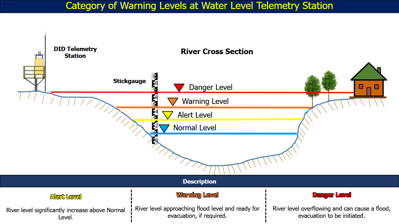
| No. | Station Name | Division | River Basin | Last Update Time | Water Level (m) | Normal Level (m) | Alert Level (m) | Warning Level (m) | Danger Level (m) |
| 91. | Kuala Balingian • | Mukah | Batang Balingian | 23-07-2026 03:30 | -0.60 | - | 0.80 | 1.10 | 1.40 |
| 92. | Muput • | Bintulu | Batang Tatau | 23-07-2026 03:15 | 1.70 | 0.00 | 6.50 | 7.50 | 8.50 |
| 93. | Rumah Abua • | Bintulu | Batang Tatau | 23-07-2026 03:30 | 2.22 | 1.69 | 9.31 | 10.40 | 11.31 |
| 94. | Tatau Town •• | Bintulu | Batang Tatau | 23-07-2026 03:30 | 0.43 | - | 1.93 | 2.38 | 2.97 |
| 95. | Kuala Tatau •• | Bintulu | Batang Tatau | 23-07-2026 03:30 | -0.06 | - | 0.75 | 1.05 | 1.35 |
| 96. | Sungai Sebatang • | Bintulu | Batang Kemena | 23-07-2026 03:30 | 2.84 | - | 3.26 | 4.00 | 4.26 |
| 97. | Tubau • | Bintulu | Batang Kemena | 23-07-2026 03:30 | 3.21 | - | 6.20 | 6.80 | 7.50 |
| 98. | Bintulu / Belaga Road • | Bintulu | Batang Kemena | 23-07-2026 03:30 | 4.21 | 3.00 | 9.65 | 10.15 | 10.65 |
| 99. | Kuala Binyo • | Bintulu | Batang Kemena | 23-07-2026 03:15 | 2.51 | - | 5.20 | 5.80 | 6.00 |
| 100. | Rumah Along • | Bintulu | Batang Kemena | 23-07-2026 03:30 | 2.40 | - | 5.00 | 6.00 | 7.00 |
| 101. | Sebauh • | Bintulu | Batang Kemena | 23-07-2026 03:30 | 0.55 | - | 1.27 | 1.57 | 1.97 |
| 102. | Bintulu Kastam Wharf •• | Bintulu | Batang Kemena | 23-07-2026 03:30 | 0.33 | - | 1.00 | 1.60 | 2.10 |
| 103. | Sungai Sibiu •• | Bintulu | Batang Kemena | 23-07-2026 03:30 | 0.38 | - | 3.30 | 4.30 | 5.30 |
| 104. | Sungai Similajau •• | Bintulu | Sungai Similajau | 23-07-2026 03:30 | 3.75 | 4.00 | 8.00 | 9.00 | 12.00 |
| 105. |
Kuala Tutong
|
Miri | Batang Suai | 23-07-2026 03:15 | 0.92 | - | 2.50 | 2.70 | 2.90 |