![]() Latest Water Level
Latest Water Level
![]() Latest Water Level
Latest Water Level
Table generated at 03:35 AM, 23-Jul-2026
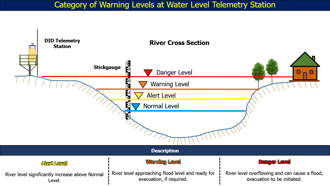
| No. | Station Name | Division | River Basin | Last Update Time | Water Level (m) | Normal Level (m) | Alert Level (m) | Warning Level (m) | Danger Level (m) |
| 76. | Bintangor •• | Sarikei | Batang Rajang | 23-07-2026 03:30 | 0.39 | - | 2.48 | 2.60 | 3.30 |
| 77. | Sarikei DID •• | Sarikei | Batang Rajang | 23-07-2026 03:30 | -0.12 | - | 2.70 | 3.00 | 3.30 |
| 78. | Nanga Semah • | Mukah | Batang Rajang | 23-07-2026 03:30 | 2.21 | - | 4.00 | 4.20 | 4.40 |
| 79. | Paloh Bangau • | Mukah | Batang Rajang | 23-07-2026 03:30 | 2.17 | - | 5.10 | 5.30 | 5.50 |
| 80. | Daro • | Mukah | Batang Rajang | 23-07-2026 03:30 | 3.28 | - | 5.30 | 5.60 | 5.90 |
| 81. | Tanjung Kabang • | Mukah | Batang Rajang | 23-07-2026 03:30 | 4.08 | - | 5.20 | 5.40 | 5.60 |
| 82. | Mid Bruit • | Mukah | Pulau Bruit | 23-07-2026 03:30 | 3.35 | - | 4.80 | 5.10 | 5.30 |
| 83. | Matu • | Mukah | Batang Matu | 23-07-2026 03:30 | 1.40 | - | 1.74 | 2.64 | 3.34 |
| 84. | Stapang B • | Sibu | Batang Oya | 23-07-2026 03:30 | 10.53 | 10.00 | 12.20 | 13.20 | 14.20 |
| 85. | Tamin •• | Sibu | Batang Oya | 23-07-2026 03:30 | 4.24 | 5.00 | 7.00 | 7.50 | 8.50 |
| 86. | Dalat Wharf • | Mukah | Batang Oya | 23-07-2026 03:30 | 2.88 | - | 3.80 | 4.20 | 4.68 |
| 87. | Oya Water Works • | Mukah | Batang Oya | 23-07-2026 03:30 | 1.40 | - | 4.00 | 4.50 | 5.00 |
| 88. | Selangau B •• | Sibu | Batang Mukah | 23-07-2026 03:30 | 12.36 | 12.00 | 16.90 | 17.20 | 17.90 |
| 89. | Nanga Lemai B • | Sibu | Batang Balingian | 23-07-2026 03:30 | 2.43 | - | 2.80 | 3.10 | 3.80 |
| 90. | Sungai Bawan • | Mukah | Batang Balingian | 23-07-2026 03:15 | 2.28 | - | 3.50 | 4.40 | 4.70 |