![]() Latest Water Level
Latest Water Level
![]() Latest Water Level
Latest Water Level
Table generated at 03:34 AM, 23-Jul-2026
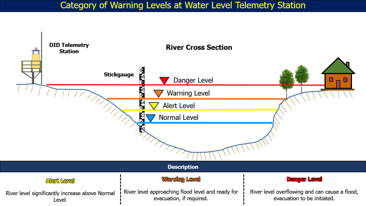
| No. | Station Name | Division | River Basin | Last Update Time | Water Level (m) | Normal Level (m) | Alert Level (m) | Warning Level (m) | Danger Level (m) |
| 46. | Giam Pasang B • | Kapit | Batang Rajang | 23-07-2026 03:30 | 3.32 | 3.00 | 5.00 | 5.50 | 6.00 |
| 47. | Nanga Merit • | Kapit | Batang Rajang | 23-07-2026 03:15 | 18.49 | 18.00 | 20.00 | 23.00 | 24.00 |
| 48. | Telok Ngelengkung • | Kapit | Batang Rajang | 23-07-2026 03:15 | 5.14 | 4.60 | 11.30 | 12.30 | 13.50 |
| 49. | Nanga Entawau • | Kapit | Batang Rajang | 23-07-2026 03:30 | 6.20 | 6.20 | 11.30 | 12.30 | 12.80 |
| 50. | Gaat B • | Kapit | Batang Rajang | 23-07-2026 03:30 | 32.75 | 32.00 | 42.50 | 44.50 | 46.50 |
| 51. | Telok Buing • | Kapit | Batang Rajang | 23-07-2026 03:15 | 3.60 | 1.98 | 10.00 | 11.00 | 12.00 |
| 52. | Kapit New Headworks • | Kapit | Batang Rajang | 23-07-2026 03:30 | 10.77 | 10.00 | 12.10 | 15.00 | 15.80 |
| 53. | Kapit Town • | Kapit | Batang Rajang | 23-07-2026 03:30 | 10.76 | 10.00 | 11.90 | 14.55 | 15.30 |
| 54. | Nanga Sebatu • | Kapit | Batang Rajang | 23-07-2026 03:30 | 6.12 | 5.00 | 11.00 | 14.00 | 15.00 |
| 55. | Song B •• | Kapit | Batang Rajang | 23-07-2026 03:30 | 7.31 | 5.59 | 10.59 | 11.59 | 12.59 |
| 56. | Nanga Ayam •• | Sarikei | Batang Rajang | 23-07-2026 03:30 | 7.47 | 7.20 | 18.45 | 18.95 | 19.45 |
| 57. | Nanga Machan B • | Sibu | Batang Rajang | 23-07-2026 03:30 | 2.65 | 3.00 | 8.00 | 9.00 | 10.00 |
| 58. | Nanga Kabah • | Sibu | Batang Rajang | 23-07-2026 03:30 | 2.08 | - | 6.29 | 7.04 | 7.79 |
| 59. | Kanowit Town •• | Sibu | Batang Rajang | 23-07-2026 03:30 | 2.23 | 1.80 | 4.59 | 4.89 | 5.59 |
| 60. | Durin Bazaar •• | Sibu | Batang Rajang | 23-07-2026 03:30 | 2.27 | - | 3.50 | 3.80 | 4.50 |