![]() Latest Water Level
Latest Water Level
![]() Latest Water Level
Latest Water Level
Table generated at 03:34 AM, 23-Jul-2026
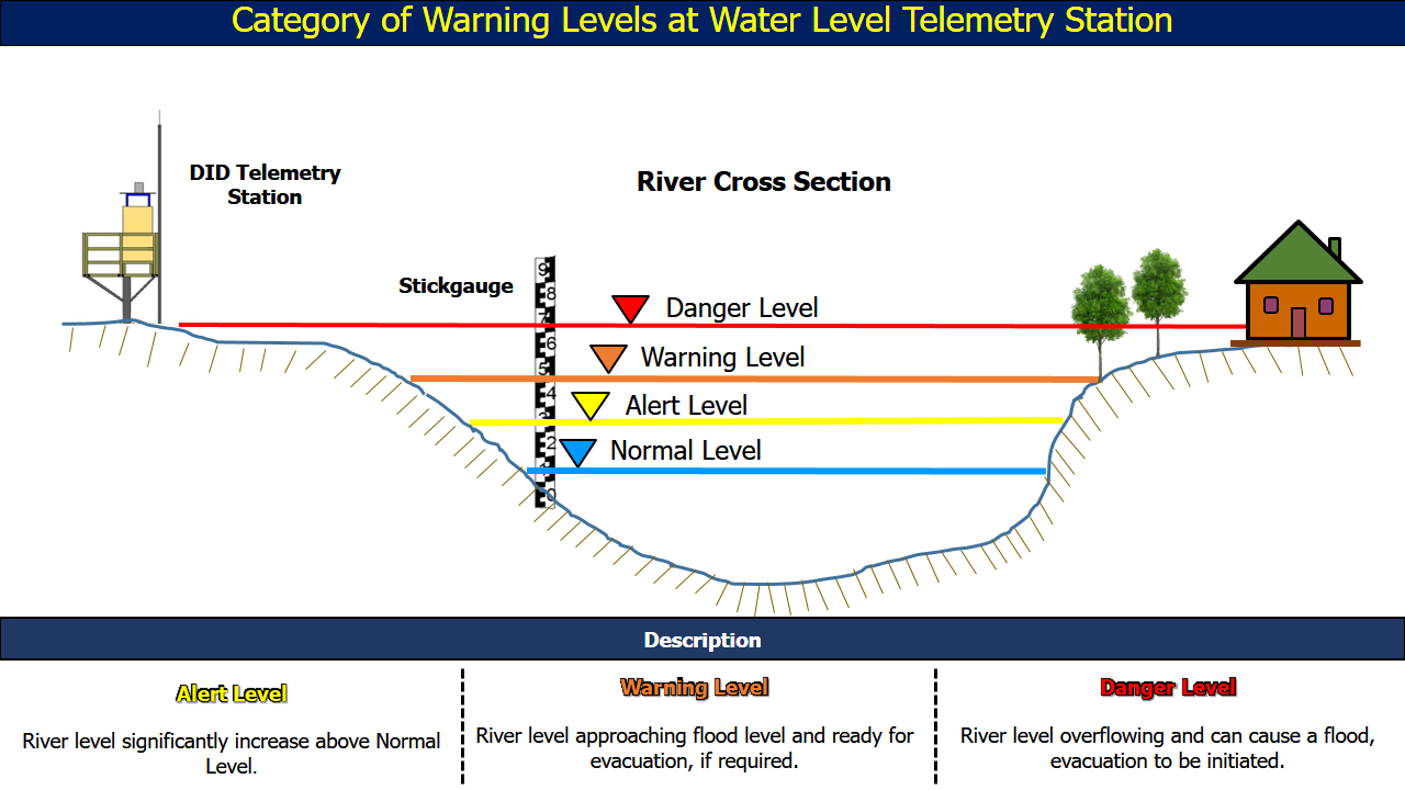
| No. | Station Name | Division | River Basin | Last Update Time | Water Level (m) | Normal Level (m) | Alert Level (m) | Warning Level (m) | Danger Level (m) |
| 31. | Sabal Kruin •• | Samarahan | Batang Sadong | 23-07-2026 03:30 | 3.88 | 4.84 | 6.91 | 7.52 | 8.32 |
| 32. | Nanga Delok • | Sri Aman | Batang Lupar | 23-07-2026 03:15 | 6.13 | 9.50 | 23.25 | 23.75 | 24.05 |
| 33. | Bau Sungai • | Sri Aman | Batang Lupar | 23-07-2026 03:15 | 13.26 | 13.30 | 16.00 | 17.00 | 20.00 |
| 34. | Lubok Antu •• | Sri Aman | Batang Lupar | 23-07-2026 03:30 | 22.54 | 22.69 | 25.32 | 25.72 | 26.32 |
| 35. | Enteban 2 •• | Sri Aman | Batang Lupar | 23-07-2026 03:30 | 0.30 | 0.40 | 8.00 | 9.00 | 10.00 |
| 36. | Engkilili JKR Wharf • | Sri Aman | Batang Lupar | 23-07-2026 03:30 | 4.63 | - | 8.80 | 9.43 | 9.79 |
| 37. | Sri Aman Telemetry •• | Sri Aman | Batang Lupar | 23-07-2026 03:30 | 2.58 | - | 4.90 | 5.20 | 5.50 |
| 38. | Pantu •• | Sri Aman | Batang Lupar | 23-07-2026 03:30 | 2.22 | 1.80 | 4.90 | 5.58 | 6.30 |
| 39. | Nanga Lubau • | Betong | Batang Saribas | 23-07-2026 03:30 | 1.38 | 1.25 | 9.32 | 10.32 | 10.92 |
| 40. | Nanga Samu • | Betong | Batang Saribas | 23-07-2026 03:30 | 4.06 | 4.20 | 7.49 | 8.09 | 9.79 |
| 41. | Betong • | Betong | Batang Saribas | 23-07-2026 03:30 | 2.30 | - | 4.86 | 5.16 | 5.76 |
| 42. | Pusa •• | Betong | Batang Saribas | 23-07-2026 03:30 | 0.88 | - | 2.62 | 3.22 | 3.82 |
| 43. | Kaki Wong • | Betong | Sungai Krian | 23-07-2026 03:30 | -0.90 | -0.84 | 5.13 | 5.73 | 6.33 |
| 44. | Roban • | Betong | Sungai Krian | 23-07-2026 03:30 | 3.13 | - | 4.60 | 5.00 | 5.20 |
| 45. | Long Sambop B • | Kapit | Batang Rajang | 23-07-2026 03:30 | 8.16 | 6.00 | 15.86 | 16.85 | 19.12 |