![]() Latest Water Level
Latest Water Level
![]() Latest Water Level
Latest Water Level
Table generated at 04:20 AM, 23-Jul-2026
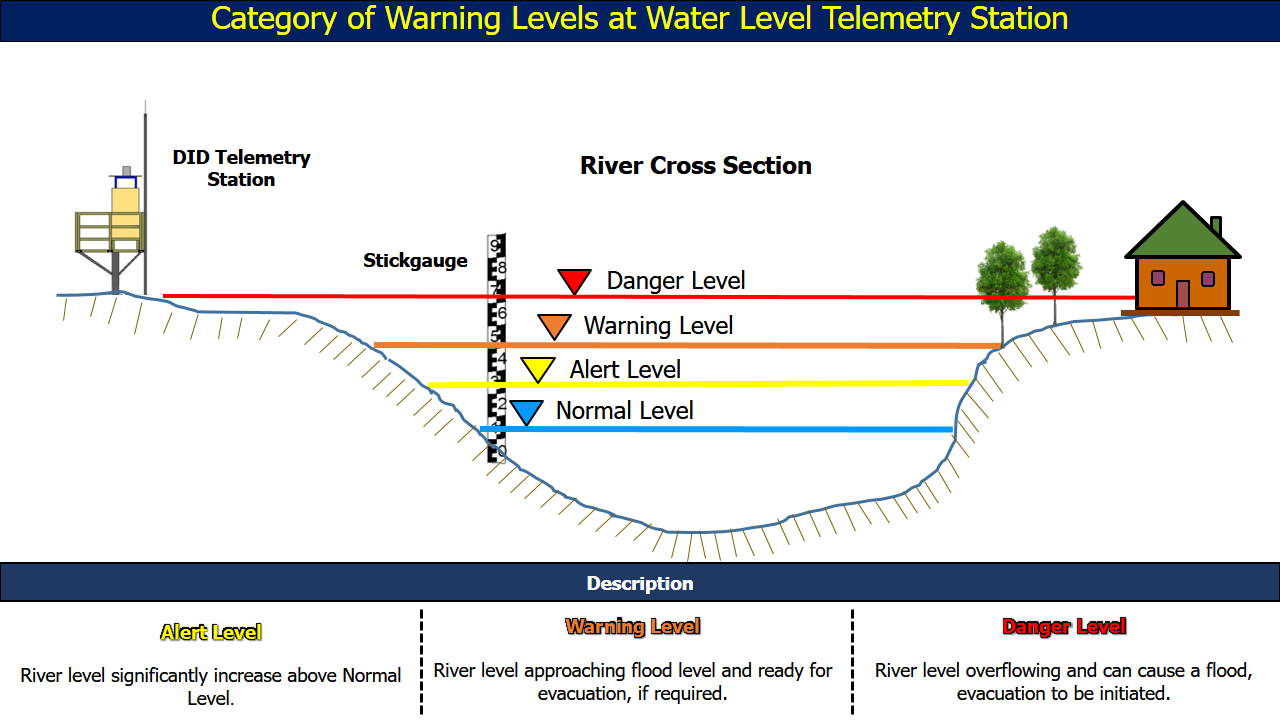
| No. | Station Name | Division | River Basin | Last Update Time | Water Level (m) | Normal Level (m) | Alert Level (m) | Warning Level (m) | Danger Level (m) |
| 61. | Stabau •• | Sibu | Batang Rajang | 23-07-2026 04:15 | 2.40 | - | 3.50 | 3.74 | 4.30 |
| 62. | Sungai Salim B •• | Sibu | Batang Rajang | 23-07-2026 04:15 | 2.20 | - | 2.65 | 2.80 | 3.10 |
| 63. | Sungai Seduan •• | Sibu | Batang Rajang | 23-07-2026 04:15 | 1.98 | 1.60 | 3.40 | 3.70 | 4.00 |
| 64. | Permai Jaya •• | Sibu | Batang Rajang | 23-07-2026 04:15 | 1.81 | - | 3.10 | 3.40 | 3.70 |
| 65. | Sungai Teku •• | Sibu | Batang Rajang | 23-07-2026 04:15 | 1.20 | - | 2.60 | 2.78 | 3.20 |
| 66. | Ulu Sungai Merah •• | Sibu | Batang Rajang | 23-07-2026 04:15 | 1.63 | - | 2.20 | 2.29 | 2.50 |
| 67. | Sungai Merah •• | Sibu | Batang Rajang | 23-07-2026 04:15 | 1.24 | - | 2.80 | 3.00 | 3.10 |
| 68. | Jabatan Laut •• | Sibu | Batang Rajang | 23-07-2026 04:15 | 1.29 | - | 2.30 | 2.48 | 2.90 |
| 69. | Sarawak Maritime •• | Sibu | Batang Rajang | 23-07-2026 04:15 | 0.65 | - | 2.80 | 2.95 | 3.30 |
| 70. | Express Terminal •• | Sibu | Batang Rajang | 23-07-2026 04:15 | 1.20 | 0.80 | 2.50 | 2.62 | 2.90 |
| 71. | Ambas •• | Sarikei | Batang Rajang | 23-07-2026 04:15 | 2.98 | 3.18 | 6.92 | 7.42 | 7.92 |
| 72. | Sungai Bidut •• | Sibu | Batang Rajang | 23-07-2026 04:15 | 1.51 | - | 2.80 | 2.98 | 3.40 |
| 73. | Lebaan •• | Sibu | Batang Rajang | 23-07-2026 04:15 | 1.89 | - | 3.40 | 4.15 | 4.90 |
| 74. | Sungai Dausan • | Mukah | Batang Rajang | 23-07-2026 04:00 | 4.04 | - | 6.00 | 6.30 | 6.60 |
| 75. | Renan Kemiding • | Sibu | Batang Rajang | 23-07-2026 04:15 | 4.03 | - | 6.21 | 7.21 | 7.71 |